Saturday, February 24, 2018

Here we go again?

It's been a while since I've sat down and cracked open this blog.
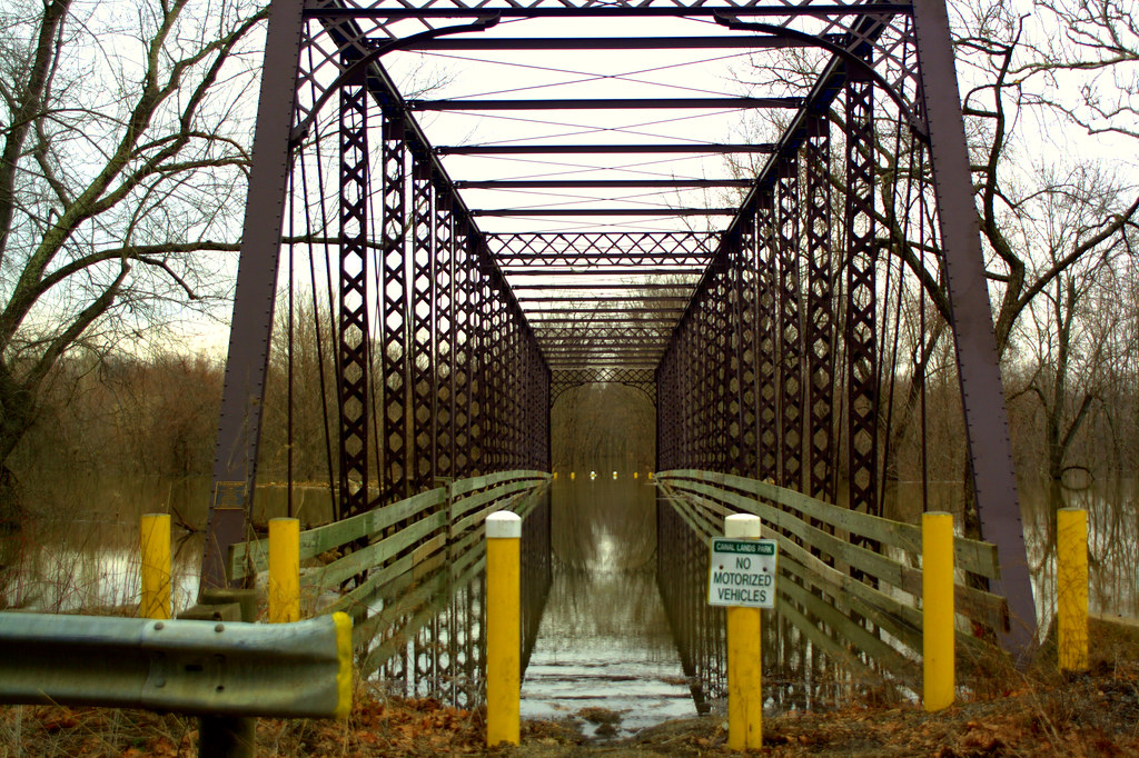
I started this blog back in 2008 to document when northern Tuscarawas County experienced 3 historic 100 year floods.  Yes, 3 floods, each 3 years apart, all "100 year" category.  The first flood in 2005 literally turned the communities of Wilkshire Hills and Zoar into an island.  Roads were impassable for nearly a month as well as the local school system was forced to close to for that same amount of time because of the waters that wouldn't recide.  Then again in 2008 another flood closed roads and schools once again, but due to the failing structural nature of the Bolivar Dam the area was still accessible both in and out as they we unable to hold back water to the north.  Again in 2011 another flood impacted the region however, that's when the real fears began for historic Zoar Village.  The levee that was built to protect the town had deteriorated due to the previous two floods and was in serious danger of failing.  Since then steps have been underway to fix what can be fixed to stabilize that levee and plans are underway to permanently repair the levee to ensure Zoar's future.  
But, fast forward to today and it seems that it's starting all over again.   
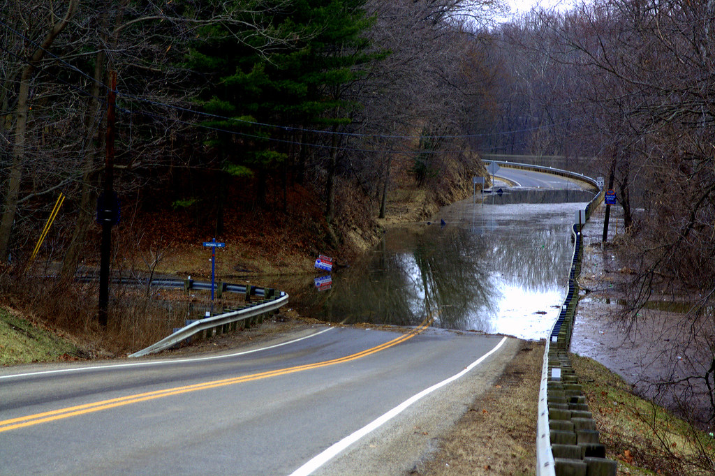
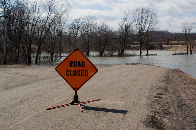
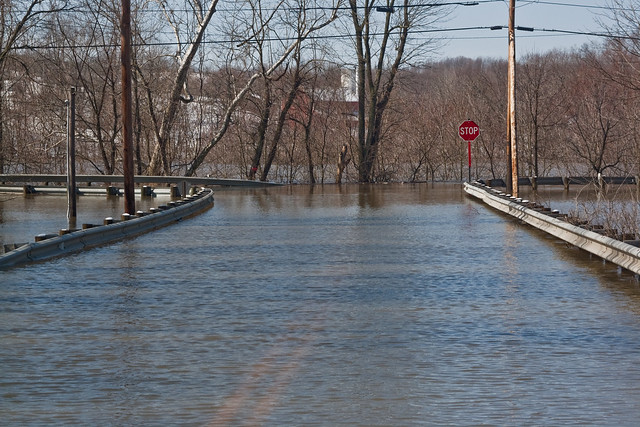
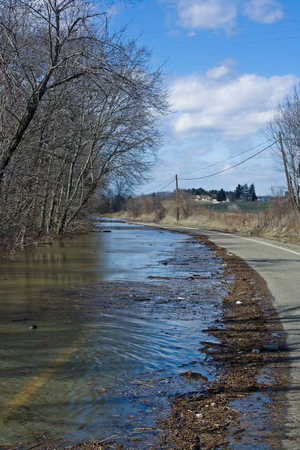
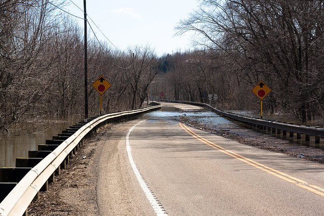
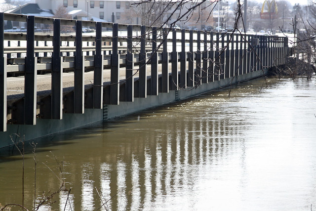
Over the past couple of weeks, heavy rain and snow have plagued northeast Ohio leading to a lot of water running into the Tuscarawas River.  With all the build up, the Army Corp of Engineers have taken measure to hold back water behind the Bolivar and Dover dams like normal to protect the towns south of the dam, (Dover, New Philadelphia, all the way down to the Muskingum River).  However, this past week has been pretty rainy and the water is really backing up once again behind the Dover Dam causing river levels to rise back into Bolivar.  According to the quick Google Map I did, that's approx 9 miles to the north.  In the past when the water gets much higher direct access to the freeway usually gets cut off due to water covering the roads.  The Tuscarawas Valley Local School District took the initiative on Friday, 2/23, to alert the area that there is a possibility school will have to be cancelled early next week due to impassable roads.
Today, (2/24/2018), the weather forecast is calling for rain this morning, some quiet, then a lot of rain tonight into tomorrow.  So far today per my meter, we've had .17 inches of rain in the Zoar area.  If we get a lot tonight it's going to be interesting to see what the water levels behind the Dover Dam rise to.  Right now, as of 10:00 am, the water levels behind Dover Dam are at 891 feet.  The record set in 2005 was 907.35.  I hope we don't reach that high of a level, but I know it's going to be up higher before this weather system is all done with us. 
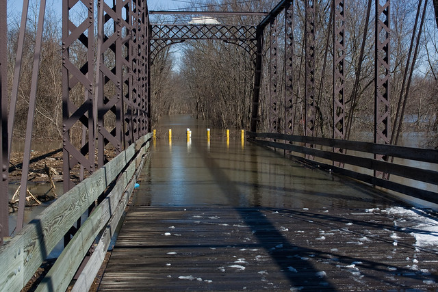
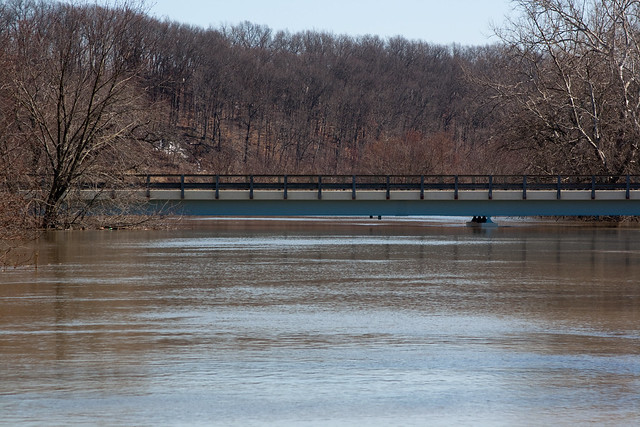
In the past, I've documented the waters from the ground with my camera.  This time, I also have a drone and will be sharing images from the air.  Stay tuned for more and don't forget to check out the local Tuscarawas weather forecasts on the Tuscarawas Weather Network's site!  I've also updated the links on this blog to give up to the minute information on both the Bolivar and Dover dams.
Here's some video I shot yesterday over the Dover Dam and Zoar. (I thought the surfing music was a nice touch.)


Tuesday, April 3, 2012

Save Historic Zoar!

I started this blog several years back to tell the tales about life inside an area that was seemed like it was becoming a bi-yearly event of getting flooded out.  A bit a truth and a little light-hardheartedness was the attempt of this site.  However, a bigger problem arose.  The Village of Zoar is at stake here.  Because Zoar is located behind the Dover Dam, a levee was built to protect it from the waters that the dam holds back.  Mind you, when the planners of Zoar put together the plan for the town in the 1800's they knew that they were upriver from the natural flood plain.  But now due to the repeated high water that have occurred, the levee is in major trouble.  The US Army Corps of Engineers has listed the levee as one that must be fixed.  But due to government regulations put in place after Katrina, there is an extensive process that must be followed.  This process could, unfortunately, mean the end of the Village of Zoar.  That's not what anyone around here wants to see.  The easy solution of course would be to tear down the Dover Dam and allow the areas downstream to flood.  Like nature intended.  But, that is not something the government wants to see, nor the residents of Dover or New Philadelphia.  What needs to be done is to fix the levee and protect this historical landmark.  And you can help protect it.  Check out the site Save Historic Zoar and find out what you can do.   This town is worth saving. I don't live in the village limits, but I am within walking distance and go down there frequently.  It's the subject of many of the pictures I take on my photo site TuscPics.Com.  The future of the village can be saved if we act.  So do it now!

Sunday, April 10, 2011

The waters are gone, for the most part

Sunny and the mid 80's.  A good day to go view the aftermath of the flooding and to give some perspective.  It's hard to think that just a few weeks ago where Molly is standing, there was water.  And a LOT of it.  Molly stands at 5' 4".  Where I'm standing at the top of the stairs was under about a foot of water.  Made it through another flood.  Let's hope that this is the last for a while

Friday, March 18, 2011

Looks like one last update for this round of flooding fun

We got the call this afternoon from the school district.  The kids go back on Monday.  Huzzah!  We did a quick drive around tonight and saw that indeed the water level is going down.  The Zoar Bridge is about as flooded as it was at this time last week.  From what we've heard, the folks that live on Michael Lane are now able to get out without having to go through water.  St. Rt. 212 still remains closed for now.  The state troopers are heavily patrolling the area and ticketing anyone that goes around the high water/road closed signs, so I dared not go around the one sign.  Which was good because as we came up to it, a trooper was coming out from the closed area.
So, we made it though another one.  Let's hope that this is that last one for a long while.  Or, at least another three years.

Tuesday, March 15, 2011

Possibly not good news for graduating Seniors from TVLS

One of the annoying effects of the flood is that the kids are missing school because of this flooding.  Today, district superintendent Mr. Mark Murphy made the following statement.

Photo credit:Tusky Valley Local Schools website

(The water in the picture above is a lot higher then it was Saturday)
"Our most recent update from the US Army Corps of Engineers indicates that it is highly probable that flooding will force the district to be closed for the duration of this week.  As you know, numerous township and county roads in the TV district are flooded and impassable.  In addition, State Route 212, the main thoroughfare of the district running east to west, is flooded in several locations.  Transportation is literally severed in multiple locations throughout the entire district. As I’ve mentioned before, to ensure the safety of all students and staff, school will be closed until further notice from me using the phone notification service.

In addition, until official notification is given that school is back in session, all district and school-sponsored extra-curricular activities, practices, rehearsals, and events will be canceled. 

Lastly, to ensure compliance with law and Ohio Department of Education requirements, the graduation date and end of the year schedule for seniors are under close review by Mrs. Huth and our guidance office.  Seniors and parents will be notified about potential changes once school is back in session.  

Again, on behalf of our Board and staff, I thank you for your patience and cooperation.  I encourage all students to remain mentally active.  Read ahead, brush up on math work, complete assignments, help around the house and in your neighborhood, and take advantage of community service opportunities."
Source: http://www.tuskyvalley.k12.oh.us/Districtpage.asp

One parents opinion, (mine), send them on Saturday's to make up the lost days.

Monday, March 14, 2011

Woohoo! It's leveling off!

It's looking like the worst may be over for us here in Northern Tuscarawas County!  Just looked at the levels behind Dover Dam and they are finally leveling out.  Even better news, Fox8 was in the area today shooting footage for their story they ran and they showed someone making it through the water to get out of the Cherry Hill development.  So those folks I'm sure are breathing a sigh of relief I am sure.  Hopefully the kids will not be out of school too long after all. 
For now, I will continue to post as needed.  But it looks like, for now, that we are on the downward trend.

Tusky Valley could be closed most of week, due to flooding - New Philadelphia, OH - The Times-Reporter

Ok, so now they are saying the water level will crest Tuesday. Then again, we are suppose to get rain Tuesday night into Wednesday.
"Nick Krupa, operations manager for the U.S. Army Corps of Engineers office near Dover Dam, said Sunday night water in the Tuscarawas River behind Dover Dam is projected to crest Tuesday."
Maybe it's time to start making the back roads more stable and suitable for bus transportation?

Tusky Valley could be closed most of week, due to flooding - New Philadelphia, OH - The Times-Reporter

Sunday, March 13, 2011

Things are settling off, thankfully

Just a quick update since there isn't much else to report.  It appears that the levels are slowly starting to level out like predicted yesterday.  Looking at the water going under the bridges outside Zoar, it's not rushing like it did yesterday.  I did increase overnight still and covered the old iron bridge outside of Zoar
We walked across this yesterday
The Michael Lane and St. Rt. 212 intersection is underwater, but luckily only by several inches and not feet. If the water level has crested, then it should only be a couple of days until it receeds enough for the folks living there to get in and out without any problems.
Still have yet to receive word if the kids are going to be in school tomorrow or not.  The "back way" into and out of the schools is open, but not the best of roads.  We'll probably hear something soon.  Until then, the kids will just have to wait.

UPDATE: As soon as I hit Publish Post on blogger, the phone rang. It was the schools.  They are closed until further notice. 

Saturday, March 12, 2011

Well, some good news

They don't expect the I-77 interchange to be shutdown at least. And the water should crest Sunday night.
"Based on no significant rain in the immediate forecast, Route 800 in northern Tuscarawas County and the I-77 at Route 212 interchange near Bolivar are expected to remain open, said Nick Krupa, area operations manager for the Army Corps. Recent rains and melting snow have pushed water levels higher, however, no more rain is in the forecast until Wednesday.

Because it didn’t rain Saturday, Krupa expects area lake levels to crest. The pool area behind Dover Dam is expected to crest tonight (assuming they mean Sunday night, March 13 since it is from that edition-AD) and at Bolivar Dam later this week. Although Leesville Lake is still rising, if it crests as expected today it will be about a foot higher than any time on record since 1948."

Read the whole story on The Times Reporter website via the link below.
Rising waters near Zoar force evacuation

Get out the life jackets, we're taking on water!


It's no longer a matter of if or when here in Northern Tuscarawas County, it's a happening now.  Denise, Molly and myself went all over the area this morning to see what's going on with the water levels.  Here's the breakdown.
  • St. Rt. 212 is closed from Zoar to St. Rt. 800.  SE of Zoar around the train bridge, the road is underwater.  It continues to be underwater on and off all the way down to Rt. 800.  Tusky Valley Road, the road leading to the high school and middle school, is underwater at the intersection of 212.
Tusky Valley Road and St.Rt. 212
St. Rt. 212 near Zoarville.
St. Rt. 212 near Zoarville looking towards St. Rt. 800
  • The water is starting to come up on the deck of the Zoar Bridge.  The Dover-Zoar Rd. bridge appears to have several feet before that is in trouble.
The Zoar Bridge is getting wet again
Dover-Zoar Road bridge
  • St. Rt. 212 east of 800 is about to be covered.  Water is on the road and the wind is pushing it further, along with the rising water.  That will probably be closed soon.
  • Canal Road just south of 212 is closed.
  • Michael Lane just outside of Zoar is suppose to be blocked off by tomorrow.  The water is creeping up on the road now.
St. Rt. 212 and Michael Lane, (Cherry Hill) intersection
  • Water is touching the bottom of the bridge over the Tuscarawas River on 212 near the I-77 interchange.  It doesn't look like water is going to cover it any time soon, but that all depends on what is released from the Bolivar Dam as well as whatever else we get from upstream.  The snow has REALLY melted off that we had gotten yesterday.
The bridge over the Tuscarawas River near the I-77 interchange
  •  There appeared to be at least four gates open at the Dover Dam.  They need to open another, maybe.
 
  • Roads around the Atwood Lake region are also in jeopardy of being covered soon.  The road leading to the Lighthouse Bistro is real close to being covered.  Also noted that there is no water being released from Atwood Lake.  Make sense because there is no place for it to go on the other side.  The emergency overflow has a lot of water backed up onto it towards the bottom. 
The homes south of Mineral City that are normally cut off, are.  Like I stated yesterday, nobody is dying from this.  Just an inconvenience and a bit of a pain in the rear.  One that seems to be happening about every three years unfortunately.  Would be nice if they got this figured out so it would stop happening.
Here's the full set of pictures from today.